Like Cop Rock but Doctors Instead?
Hospital Rock, Farmington
October 6, 2007 April 27, 2009
This page was inhabited for 2 years by a post whining about how I haven’t actually been to Hospital Rock and how maybe someday I’d go in search of it. Well, my search was made a heck of a lot easier by a CTMQ reader who supplied me with detailed directions to the rock. A big thank you to her, as my search would have been about a mile off to the north and west – for no other reason than my gut was wrong.
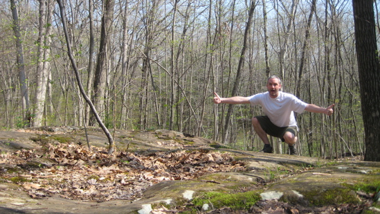
And so, after nearly two years of wondering where Hospital Rock was – and coming across a few mentions of it here and there, I hiked in to it. This page gets a lot of web traffic and I get a relatively large amount of email asking me about it. What is the draw? Why are other people besides me seemingly fascinated by this rock? Why can’t anyone find it?
That last question is the easiest to answer – because “they” don’t want you to find it. “They” being the Farmington Historical Society and other preservationist entities interested in protecting the rock; not an easy task when you think about it. Everyone knows the vicinity of the rock – the swath of woods surrounded by Farmington, Plainville and New Britain is accessible to tens of thousands of people. It’s bounded by I-84 and routes 4, 10, and 372 and these woods are scarred by many ATV and Jeep trails. A cool section of the Metacomet Trail passes nearby that includes such popular areas as the old Nike Missile Base, Pinnacle Rock, Will Warren’s Den, and Rattlesnake Mountain. Heck, 50 Cent’s mansion is relatively close, albeit on the other side of Route 6. (All that cool stuff is here, on our Metacomet Trail Section 8 hike.)
So I understand the wishes to keep this rock’s location secret. It would only take one idiot to destroy it and its attendant history. Some preservationists actually state publicly that the rock is no longer even there. Well… It is. But I must say off the bat – the rock itself is a bit anticlimactic.
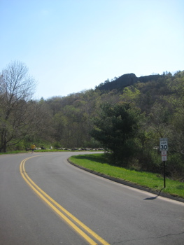
So where’s the rock? Ha! It’s actually quite easy to find once you know where to look and while it’s further off the Metacomet Trail than I had thought, but it’s still very close to some other, mostly unmarked trails. I used to offer up a set of directions but I’m no longer doing so. It’s not that I don’t want to help people out, it’s that half the requests were goofy lies and furthermore, I’m no longer confident my now rather old directions are still accurate.
I parked at the ultra-secret location (It can be accessed from Plainville or Farmington) with about 60 No Parking signs located at the trailhead. I took care to drive further to a safe spot, but did notice two other cars in danger of being towed. Now, before anyone thinks this No Parking zone is to keep people away from Hospital Rock, it’s not.
I figure A) This would be a good access point for teenagers to park and go “experiment” and the signs discourage that, B) the well-heeled crowd who lives there doesn’t want their road to be a parking lot, C) it discourages ATV usage, and D) there is a challenging rock climbing spot 5 minutes into the woods and the town doesn’t want blood on their hands.
All much more viable reasons than protecting a rock that relative few people know about.
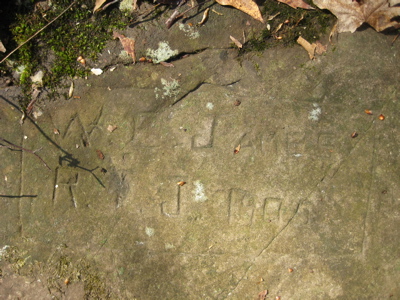
I walked in the woods, up the hill, crossed paths with the Metacomet, down the hill, turned this way and then that and after only maybe 15 minutes, I was there! Hospital Rock! Right beneath my feet! This would be a good time to explain what the heck I was standing on.
Excerpted from the definitive article on the rock, from Hog River Journal:
Hidden deep in the second-growth hardwood forest of Rattlesnake Mountain is an inconspicuous flat ledge of traprock. On it are carved 66 names of long-ago Farmington residents. This is Farmington ‘s “Hospital Rock,” and it marks the site of Eli Todd and Theodore Wadsworth’s smallpox inoculation hospital of the 1790s. It is a reminder of the terrible epidemics of another day, and of the efforts of local physicians to halt their spread.
In colonial New England villages like Farmington, smallpox epidemics were infrequent, but the inhabitants were more susceptible than city dwellers when outbreaks did occur. A rural population would become immune as the result of infection, and another outbreak would not occur until five to 20 years later, when a critical mass of susceptible people was again present. The larger towns and cities, on the other hand, experienced small outbreaks of the disease with such frequency that it was almost endemic. Their populations carried a high level of immunity and were protected for life after a childhood infection. The grim folk wisdom was that one’s child was not one’s own until it had survived smallpox. Most children did in fact survive, and their mortality was lower than that of adults, for whom the death rate was 20 to 30 percent.
…
John Adams called smallpox “The King of Terrors,” and Thomas McCaulay referred to it as “The most terrible of the ministers of death.” Gurdon Buck’s 1858 medical textbook referred to it as “the most loathsome and fatal disease known to man.”
…
Eli Todd (1769-1833) was the well-to-do son of a New Haven merchant. He was a brilliant honors graduate of Yale who had studied medicine with Dr. Ebenezer Beardsley of New Haven under the old apprentice system. He had begun practice in Farmington at the very young age of 21, and had gained the respect and love of his many patients. His were gentle treatment methods in an age of harsh remedies. His skill, kindness, and cultivation made him the favorite practitioner of the emerging wealthy class in the community. In 1792, when he joined with Theodore Wadsworth to establish the “hospital” on Rattlesnake Mountain , Todd was a hard-working 23-year-old bachelor.
…
The hospital building stood on a stony hillside known as the “goat pasture” on Settlement Road , the old road to New Britain . The land on which the hospital was situated is believed to have belonged to the Josiah Kilbourn family, and was purchased in 1798 by Elias Brown. Both families evidently had farm buildings near the site. However it is unknown at present whether the hospital had been a farmhouse or outbuilding, or was a specially built structure. It was far from both town centers, but easily accessible for attendants and visitors with immunity. Rattlesnake Mountain sheltered the building from north winds that would otherwise chill the patients during the autumn months. Our only description of the structure comes at second hand from a patient’s grandchild, who described a long narrow building standing somewhat off the road near a spring. Inoculations were done only from about May until October, and there was no need for fireplaces.
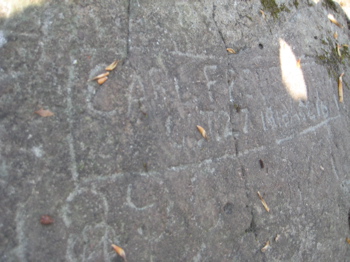
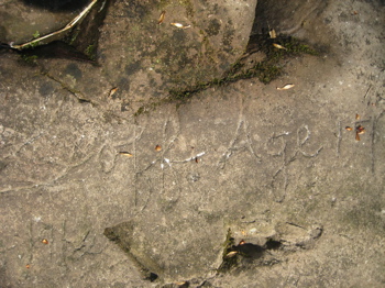
Near the hospital building was a smooth sunny ledge on which the young patients could socialize, and where they picked up messages and packages from home. Of the hundreds who must have stayed at the hospital in the years 1792, 1793 and 1794, sixty-six have left us their names or initials cut into the ledge. It is smooth, flat and slopes down away from the old roadway. Scattered on the rock’s surface in an irregular area about 15 by 20 feet, the names are barely discernible until a visitor dusts them with flour. Then they emerge, like a photographic print materializing in a darkroom pan.
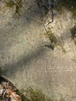
It is estimated that hundreds of patients were inoculated and spent their recovery at the Todd-Wadsworth Smallpox Hospital . Fifty-two of the 66 names carved into the rock include first, and sometimes middle, initials, and these patients can be further identified with some confidence. Considerable information is available for 26 of them. The known ages of the patients ranged from 9 to 33 years. Twelve family groups appear, and one or two parent-child pairs. The social position of the inoculees is revealing. Nineteen were descended from original proprietors of Farmington , and most appeared to come from homes of at least middling wealth. There were the children of physicians, future physicians, and future spouses of physicians.
The old Settlement Road is now abandoned, though it can be traced from the quarry on Route 6 several miles through the forest to where it is interrupted by Interstate 84. Along it innumerable fragments of traprock litter the forest floor, and there area a few hints of stone walls. Near the road and 1,000 feet from the rock itself, there is a cellar hole lined with mortarless rock and a long-abandoned well. These are the only remains so far uncovered that accompany Hospital Rock with its carved names recalling a long ago and very different time.
Hospital Rock has for two centuries rested on the periphery of Farmington history. Since even local historians have been uncertain of its location, it has acquired an aura of mystery and romance. Yet it has remained a very meaningful artifact, speaking to us in a direct and moving way from the past. In the last few years, however, there has been renewed and effective interest in its preservation. While the site is actually in Farmington , the land is owned by Hartford , which purchased it for its watershed. In 2002 the Connecticut Historical Commission declared Hospital Rock and the surrounding forest to be an Historic Archeological Site, and Farmington is collaborating with Hartford in a move to gain easement protection for the site. An archeological search for the remains of the hospital itself is projected for the near future. There remains, however, the intriguing question of how to preserve the inscribed slab of bedrock out in the woods.
Please read the full article at the link below. There is another similar spot down in Durham called the Pest House that I’ve yet to locate… So if you know exactly where that is, I’ll tell you exactly where this is. I also know of a Smallpox cemetery in Madison and a couple other spots like that, but Hospital Rock is definitely unique.
![]()
Full Hog River Journal article

 Lawrence Ierardi says
January 8, 2008 at 2:01 pmAs a teen ager I liked to hike to the high point near the Channel 30 Tower along the Blue Tail and look over the valley toward Hartford. On at least three occasions I stopped at a place on the trail which runs parallel to Route 6 toward Plainville and examined dates, names and initials carved in a large flat rock area which ovelooks Route 6. I later learned from an article in the New Britain Herald (around 1960, I think) that this area was know as Hospital Rock. Its among several curiosity sites I visited when I lived in CT including Dudley Town (before it was closed to the public). I am 71 and hiking is a bit of a chore since I have had an artificial knee installed in my left leg but, come spring,I may want to take that hike one more time before I am called to the bigger hiking trail above. It will mean a trip to CT from NH but, if I am fit, I could give it a try but I will not go alone. Contact me and perhaps we can peruse some Survey maps for the spot. I note that a lot of quarrying has gone on in that area, I hope that the rock is still there.
 Steve says
January 8, 2008 at 5:52 pmLawrence –
I’d love to get a peek at Hospital Rock. By all accounts, it’s still there but certainly not marked. Since I was with my wife, looking under the leaves for a couple hours wasn’t about to happen. Once when I ran into a woman who used to be on the CFPA board out in Barkhamsted one day, her first question was, “Did you find Hospital Rock yet?” like it was THE test of CT coolness. I was shamed.
If you make it down here, we’ll check it out. It’s very close to my house (I’m in West Hartford) and it would be fun.
As for Dudleytown, oh it’s still there. They changed the road name and put up a bunch of warning signs, but it’s there. Hike the Mohawk Trail and you can’t avoid it (which is kind of funny to me.)
 Reed Ide says
July 28, 2008 at 12:44 pmWell, I can’t join the hike, but did think Larry Ierardi would get a kick out of knowing that Serge Kochen and i were talking about him over the weekend (July 26-27) as we took a quick nostalgia tour through Stafford Springs and drove up to the high school and around the town. There is no more Stafford Press, and we are all aging! Best Wishes!!!! –Reed Ide
 Mindy says
April 5, 2009 at 5:38 pmSteve,
Still enjoying the site since the last time we “talked”. Just wanted to let you know that we found hospital rock last weekend accidentally. Its off of the Metacomet a ways. Actually easier to get to if you hike directly up to Pinnacle Rock from Plainville. I’d be happy to give you directions if you ever want to go.
Happy hiking,
Mindy
 Katharine O'Brien says
April 17, 2009 at 6:39 amMindy,
I would appreciate the directions to the site of ‘hospital rock.’ I asked someone at the Farmington Historical Society for directions or a map and she doesn’t like to give them out because of vandalism. We’re residants of Farmington and really need clear directions, as I can get lost in my backyard!
Thank you! Katharine O’Brien
 ron says
May 1, 2009 at 5:17 pmthey come out much better with flour
my favorite name on the rock has got to be C.B. BRONSON
also someone carved the encircled word liberty
 ron says
May 3, 2009 at 7:46 amOH DID YOU FIND THE LOCATION OF THE HOSPITAL I’M PRETTY SURE I KNOW WHERE IT IS I’VE BEEN GOING UP THERE SINCE 1974 OR SO
ITS ABOUT 75 TO 100 YARD SOUTH SOUTHEAST OF THE ROCK IT SELF
THERE IS A LONG FLAT PIECE OF GROUND ABOUT 40 FEET BY 20 FEET
WITH 2 STILL FLOWING SPRINGS WITH ALL THE RESEARCH I’VE DONE
MY GUESS IS THIS IS THE SPOT
 Lawrence Ierardi says
September 28, 2009 at 7:33 amHi, I found this site by accident. I was searching for Serge and this site,
popped up. You found Hospital Rock. Great news. If you go again my advice it to take lots of photos because the area could be posted against “trespassers”. I think Connecticut needs a law to allow serious historical explorers access to such sites. The news about ATV’s concerns me. Many ATV owners are responsible folks but unfortunately not all of them are. Happy hiking.
 Jeff says
November 11, 2009 at 4:19 pmWent there today. My 8th grade daughter is doing a report for school. I pieced together your narrative with another piece, and was able to build a likely path. I said to my daughter and her friend, “You should be looking around now for an outcropping that would make sense; kind of like that one, over there.” And there it was!
There were several teenagers on motorcycles and ATV’s, tearing through the woods. I’m guessing the typical vandalous teen would never bother to walk all the way in, but with motorized transport and today’s battery powered tools, I’m surprised they haven’t hacked the rock apart. You can see some carvings from 1965 which look like a chisel was used.
Thanks for the tip on using flour to bring out the writing. The photos were much better.
Someone blazed a tree at a major intersection with a big “H” and an arrow. It doesn’t point to the rock’s location, but it gives you the right path. I’m thinking of going back and covering it up. It shouldn’t be easy.
 George says
November 22, 2009 at 8:50 amI’ve looked for Hospital Rock on two separate occasions, but nevr located it. I’d appreciate directions. In return, I can offer a similar site with many historic shale engravings, which is about 3 miles in the woods near the MA/NY/VT corner called “the Snow Hole”. The trail to the snow Hole is like riding down Rte 95 with all the signs (signs, signs, everywhere signs), but the hike is well worth it if you aspire to visit the carvings. There is a cave there, which can be entered albeit relatively short and minimal.
 George says
November 29, 2009 at 6:33 amI finally found it! It was worth the time invested in paper tracking the location to get a general idea on the location. I also got the GPS coordinates, but didn’t use them since that would be kind of cheating. Unfortunately, someone beat us to the rock the day after heavy rains and poured flour all over the wet rock. It really detracted from the visit. A hunter was also kind enough to leave all his trash near the rock including scent packaging, plastic trash bags and crap (literally).
There are obvious signs of an archeological investigation in the area. Walk around a bit. There is more to this location than just the rock!
I look forward to visiting again under better circumstances. Perhaps in the winter when traffic will be low.
 Jerry Mace says
November 30, 2009 at 11:42 amI was hiking the near the old Nike Missle Site a week or so ago and met a couple that was looking for Hospital Rock. I had never heard of it but when I got home I Google’d it and found this site. I went back the other day and hiked the Metacomet from the Oval sign on Rte 372 in Plainville all the way to Rte 6 specifically keeping an eye out for Hospital Rock but never found it. Can you give me a hint … is it closer to Pinnacle Rock or to Will Warens Den or to the TV Towers?
 Shirley Sutton says
February 2, 2010 at 3:50 pm2/2/10
Today was my 5th trip to H.R. – it is always exciting. It was snowy, but I brought a brush so we could see some of the inscriptions. UNFORTUNATELY, someone had used something permanent on the rock to better read the inscriptions. This has diminished the historical value of the site. It is due to this kind of selfish and thoughtless act that some people won’t reveal it’s location.
 Jason says
March 8, 2010 at 8:43 amI would like to find the rock to satisfy my own personal curiosity. I have been to Tory’s Den, Devil’s kitchen, the Tory Prison , the Witch Rock and several of the Leatherman caves all without having publicized anything about them. Why? Don’t imagien there is much of a market for my thoughts on such things. I just really dig quirky hisprical sites like this. If you want to ask me questions so that I may prove my worthiness please shoot me an email. thanks.
 Bert Coggeshall says
July 2, 2010 at 3:31 pmI grew up in New Britain, less than a mile from Rattlesnake Mt (as the crow flies), near what is now Stanley World HQ. One of my friends was Mayor William McNamara’a son. Mr Mac had shown him Hospital Rock, and he in turn took me to see it. That was about 40 years ago. I’ve been trying to find it (I was 9 or 10 at the time). I’m glad you found it. I new its history. I’ve wanted to show it to my kids and see it again myself (I’m a history buff). If you could help me out, I would greatly appreciate it. If, not, I still enjoyed your site and description.
 Tyler says
July 5, 2010 at 12:43 pmI am a Plainville resident, and hike this area often. I am very familiar with local history of this area, and have heard about Hospital Rock, but I have never actually been there. One of my friends remembers going there with the Plainville Conservation Commission, but can’t remember how to get to it. I would love to know the location of this, and would never think of vandalizing the site. I would greatly appreciate it if you could get back to me with an email. You can ask further questions of me to prove my worthiness, too. Thanks.
 martin says
October 27, 2010 at 10:59 amive seen it many times, its pretty easy to get to i figure giving directions on here isn’t a big deal because the people who vadalize most likely don’t go on this site anyways.
i would love to see the rest of the hostpial remains, didn’t even know that they were near the rock.
Someone told me once that somewhere on the mountain there is a mine that was used for by the colonial soilders to hold British troops as prisoners, anyone heard this before?
 Brian says
November 4, 2010 at 9:20 pmLiving on just off of metacomet trial in plainville a few years ago we joined the plainville conservation on a hike up to the missle base and had the opportuity to visit H.R. I would like to show my children a part of history. I recall the direction we headed in but don’t remember it’s location. Could you please provide a little more direction..
Thanks
 Bruce says
November 21, 2010 at 12:28 pmI have hiked from Rte 372 to Rte 6 a few times lately looking for a remembrance of how to get to the site to no avail(I was there as a 5 year old).
I am trying to revisit the first time i went there and would appreciate some guidance.
Thanks for any help.
 Gloria says
December 18, 2010 at 3:51 pmi too have an 8th grader that needs to find the rock for a research project and we’ve had no luck. would appreciate some guidance on where to even start!
 Karen says
May 8, 2011 at 3:25 pmJust up hiking the Metacomet trail today. Anyone give me some idea where hospital rock is? Would love directions. Plainville resident. What is wrong with all these kids who trash our woods. Beer bottles and spray paint all over Pinnacle Rock.
 Edward Rabenold says
June 22, 2011 at 9:30 pmI took some time after leaving the army where I served as a construction surveyor, and mapped out all the stage coach trails, the Blue Trail, and the fire roads that criss-cross the area. I also located all the stone walls, and the foundations of the Elias Brown tract,which is near the Hospital Rock-all to get a sense of what this area may have looked like in colonial times. I also located a few springs in the area, in an effort to locate the actual hospital site. I lived on Metacomet road, and have been visiting the Hospital Rock since October 1974, when a guide revealed the location to our town historian, Ruth Hummel, Before that time, most people had forgotten it’s wheaerabouts. God forbid the ATV vandals should ever trouble themselves to find this spot. People who say they are looking for the rock these days, shoul submit to a background check first.
 Matt Rogers says
December 23, 2011 at 8:45 amMy son and I would love directions. He is 7. We were up near there last Saturday. Thank you.
 Jim says
February 14, 2012 at 4:25 pmGlad you didn’t use flour and a brush. It would only invite further deterioration. Use of flour, chalk, shaving cream is frowned on for gravestones. While this isn’t a gravestone, the bad effects of using those methods is the same. Check out findagrave dot com’s forums for more info.
 t. conners says
June 10, 2012 at 7:59 amhttp://youtu.be/mPt1nxrt-vQ?hd=1 video on hospital rock.
 s. kahn says
October 6, 2012 at 9:03 pmMy friend and I have been searching for the Pest House in Durham. If anyone has directions it would be much appreciated! There are many differing accounts as to its exact location, and I’ve been doing my best with Google Earth and up to this point. It would be very creepy but awesome to see!
 Paul Dube says
November 15, 2012 at 7:45 pmI, too, grew up in New Britain and found Hospital Rock on one of my hikes across (or under) I-84. One of the above commenters, Bert Coggeshall, grew up across the street from me and we used to head up there together. I remember searching for the hospital site and finding a stone wall as well as a few prospective flat areas where it could have existed. I would love to make the trip back sometime-winter is the best time as there seems to be an overwhelming abundance of ticks in that area during the summer.
 Deb L. says
November 30, 2012 at 8:04 amGreat article! We have to hike up there soon for an 8th grade project on medicine in history – we promise not to use flour, or anything else, just a camera! Can you e-mail me the directions? I’d appreciate it.
 Steve says
November 30, 2012 at 8:34 amI no longer give directions to Hospital Rock. One, because it’s been years and who knows if my landmarks are accurate anymore and two, everyone loves a good mystery.
 Bruce says
December 23, 2012 at 8:05 pmWell the rock is still there. Hiked there this weekend. Someone was there earlier with lots of flour. I too have searched in the past for the actual hospital location and have seen the rock ledge south and east of the rock. No signs of the actual structure but then again I didn’t spend a lot of time looking.
 Joe Silverio says
March 30, 2013 at 5:48 pmCan anyone please send me the coordinates? We are attempting to hike there tomorrow after Easter Dinner. Thanks.
 Jim says
April 20, 2013 at 11:10 pmFound it today while geocaching. Very interesting, you could walk right over it without noticing.
 Bryan says
July 13, 2013 at 5:47 pmI’ve hiked that section of the Metacomet trail and looked for Hospital Rock several times, but without any luck. I’m actually going to be leaving the area by the fall, and would love to check it out before moving. Would anyone be willing to contact me with directions?
 Frank D says
April 27, 2015 at 8:29 amHave been there many times years ago but would have some trouble finding it again. Too bad erosion has already taken a toll on the carvings. Always thought it should be protected somehow.
 Edward Rabenold says
April 1, 2017 at 9:18 amI went up to the Hospital Rock last year. A hiker was standing on the stage trail five feet from the rock with his GPS and not a clue as to how close he was to his destination. I have been travelling up there since 1974, when Plainville historian Ruth Hummel first made public it’s location after an old timer offered to show her where it was. Before that time, it’s location had been a mystery for many decades to all but a few persons.She has led many field trips up to it since, and she and I have made attempts to find the nearby site of the actual pest house.. Sadly, the rock has already been vandalized by unthinking and uncaring idiots who attempted to carve out a slice of their own immortality by scratching their names across the rock carvings. This area is a state historical preserve, so this is and should be considered by all a crime. I refuse to travel up to the site. or lead any of my friends there again, as I am heartbroken over what has been done to this landmark. And it’s desecration is likely to continue. How sad… Ruth should have thought seriously about the consequences of her decision to share it’s location so many years ago. Another sign off the sad times in which we live.
 dan says
November 30, 2017 at 3:10 pmI go up there on a regular basis and have not seen any evidence of vandalism. I haven’t done a close inspection but just some flour or other white powder type substance, the worst part about that is just how much the white draws peoples attention to it, other wise its only 10 feet off the trail but would go un-noticed by most. Another poster commented that he would examine names and dates carved into a rock overlooking route 6. That is not hospital rock as it is not near route 6 at all. The writer of this article mentioned that after 12 minutes he reached the rock after parking on Metacomet road. I can’t imagine how that would be remotely possible. I would venture a guess of a 30 to 45 min. walk if you knew exactly where you were going and walking at a brisk pace. It is not near the meatcomet trail at all. The metacomet runs along the ridge of Pinnacle rock and rattlesnake mountain. Hospital rock is aprox 1/2 way down the slope from that ridge towards deadwood swamp which is the starting point for the Quinnapiac river. Lastly another poster talked about the “ATV Vandals” I am up there with great frequency and have only crossed path with someone riding an ATV two times and they were pleasant and friendly. Stopped to talk with me and pointed me in the right direction. Anyone can be a vandal, riding an ATV has nothing to do with it. As a matter of fact, many of the old logging trails up there exist still, only because of ATV usage.
 Jessica Wysocki says
June 9, 2023 at 11:07 pmThe historical society knows where the pest house is
https://patch.com/connecticut/durham/hike-to-the-pest-house
 Holly Baldydga says
January 10, 2024 at 2:27 pmMy family drove across Hospital Rock many times as we lived out there;, just west of the rock, during the late 1940’s thru 1955. It was an old dirt road, called Settlement Road, or Old Settlement Road, which we reached from the west end of Osgood Avenue in New Britain, as we crossed a gas pipeline, which I believe is alongside I-84 now, and then a brook.
I believe there are still parts of foundations since there were 5 or 6 houses west of the pipeline on that road, that I remember. The Lagosz family owned a mink farm just past the pipeline, I lived in one of the 5 houses past them.
I’d love to visit the site, hopefully in the spring I can gather up a few hiking friends to do this..